
Thank you for supporting this site ❤️
Make a donation
Make a donation
Sham Tseng Village topographic map
Click on the map to display elevation.
Thank you for supporting this site ❤️
Make a donation
Make a donation
About this map
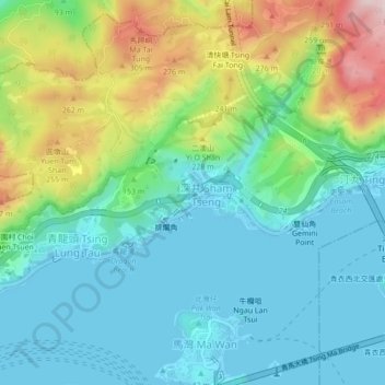
Name: Sham Tseng Village topographic map, elevation, terrain.
Average elevation: 99 m
Minimum elevation: -2 m
Maximum elevation: 358 m
Thank you for supporting this site ❤️
Make a donation
Make a donation
Other topographic maps
Click on a map to view its topography, its elevation and its terrain.
Tai Lam Chung Catchwater Section M
China > Hong Kong > Tsuen Wan District > Sham Tseng Sun Tsuen
Average elevation: 181 m