
Thank you for supporting this site ❤️
Make a donation
Make a donation
High Ridge topographic map
Click on the map to display elevation.
Thank you for supporting this site ❤️
Make a donation
Make a donation
High Ridge
A post office called High Ridge has been in operation since 1856. The community was so named on account of its lofty elevation.
Thank you for supporting this site ❤️
Make a donation
Make a donation
About this map
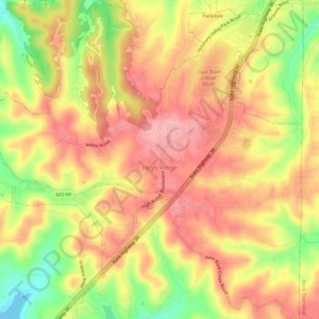
Name: High Ridge topographic map, elevation, terrain.
Average elevation: 242 m
Minimum elevation: 166 m
Maximum elevation: 291 m
Thank you for supporting this site ❤️
Make a donation
Make a donation
Other topographic maps
Click on a map to view its topography, its elevation and its terrain.