
Make a donation
Miami River topographic map
Click on the map to display elevation.
Make a donation
About this map
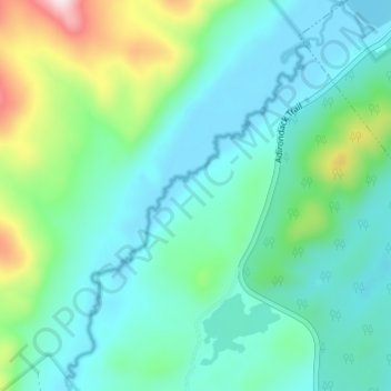
Name: Miami River topographic map, elevation, terrain.
Location: Miami River, Hamilton County, New York, United States (43.58948 -74.44776 43.63334 -74.40482)
Average elevation: 597 m
Minimum elevation: 501 m
Maximum elevation: 947 m
Make a donation
Other topographic maps
Click on a map to view its topography, its elevation and its terrain.
Village of Speculator
United States > New York > Hamilton County > Town of Lake Pleasant
Speculator Mountain, with an altitude of 2,966 feet (904 m), is south of the village.
Average elevation: 648 m
Make a donation
Sacandaga Lake
United States > New York > Hamilton County > Town of Lake Pleasant
Average elevation: 531 m
Brown Tract Pond Campground
United States > New York > Hamilton County > Town of Inlet
Average elevation: 564 m
Make a donation
Make a donation
Make a donation
Three Ponds Mountain
United States > New York > Hamilton County > Town of Benson
Average elevation: 739 m