
Thank you for supporting this site ❤️
Make a donation
Make a donation
Dougherty topographic map
Click on the map to display elevation.
Thank you for supporting this site ❤️
Make a donation
Make a donation
About this map
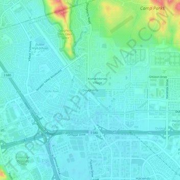
Name: Dougherty topographic map, elevation, terrain.
Average elevation: 112 m
Minimum elevation: 97 m
Maximum elevation: 184 m
Thank you for supporting this site ❤️
Make a donation
Make a donation
Other topographic maps
Click on a map to view its topography, its elevation and its terrain.
Dougherty Hills Open Space
United States > California > Alameda County > Dublin > Komandorski Village
Average elevation: 120 m