
Thank you for supporting this site ❤️
Make a donation
Make a donation
Moapa Valley topographic map
Click on the map to display elevation.
Thank you for supporting this site ❤️
Make a donation
Make a donation
Moapa Valley
Moapa Valley is at an elevation of 1,265 ft (386 m) above sea level. The United States Census Bureau gives the census-designated place (CDP) of Moapa Valley (which may not coincide exactly with the town boundaries) a total area of 43.7 square miles (113.2 km2), of which 43.7 square miles (113.1 km2) is land and 0.04 square miles (0.1 km2), or 0.05%, is water.
Thank you for supporting this site ❤️
Make a donation
Make a donation
About this map
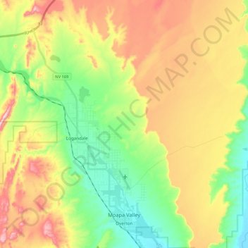
Name: Moapa Valley topographic map, elevation, terrain.
Location: Moapa Valley, Clark County, Nevada, 89021, United States (36.52096 -114.52626 36.69149 -114.38559)
Average elevation: 520 m
Minimum elevation: 370 m
Maximum elevation: 723 m
Thank you for supporting this site ❤️
Make a donation
Make a donation
Other topographic maps
Click on a map to view its topography, its elevation and its terrain.