
Make a donation
Bundi topographic map
Click on the map to display elevation.
Make a donation
Bundi
The town of Bundi is situated 35 km from Kota and 210 km from Jaipur. It is located at 25°26′N 75°38′E / 25.44°N 75.64°E / 25.44; 75.64 and an average elevation of 268 metres (879 feet). The city lies near a narrow gorge, and is surrounded on three sides by hills of the Aravalli Range. A substantial wall with four gateways encircles the city. It is served by Bundi railway station on Kota-Chittorgarh rail line. Bundi is also known as "Choti Kashi" as there are many old temples in the city, which has been built by kings at their reign.
Make a donation
About this map
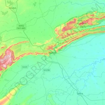
Name: Bundi topographic map, elevation, terrain.
Location: Bundi, Bundi Tehsil, Bundi District, Rajasthan, 323001, India (25.28161 75.47758 25.60161 75.79758)
Average elevation: 284 m
Minimum elevation: 224 m
Maximum elevation: 542 m
Make a donation