
Thank you for supporting this site ❤️
Make a donation
Make a donation
Malakothamuru topographic map
Click on the map to display elevation.
Thank you for supporting this site ❤️
Make a donation
Make a donation
About this map
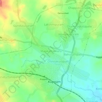
Name: Malakothamuru topographic map, elevation, terrain.
Location: Malakothamuru, Kuppam, Chittoor, Andhra Pradesh, 517425, India (12.73721 78.32301 12.77721 78.36301)
Average elevation: 688 m
Minimum elevation: 658 m
Maximum elevation: 740 m
Thank you for supporting this site ❤️
Make a donation
Make a donation