
Thank you for supporting this site ❤️
Make a donation
Make a donation
Kedungpring topographic map
Click on the map to display elevation.
Thank you for supporting this site ❤️
Make a donation
Make a donation
About this map
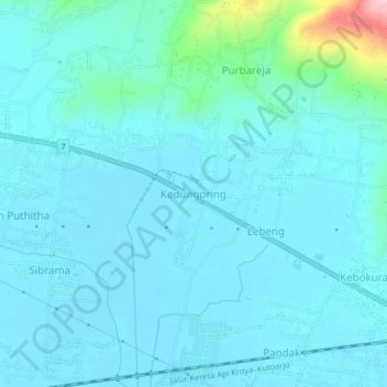
Name: Kedungpring topographic map, elevation, terrain.
Location: Kedungpring, Banyumas, Central Java, Java, 53195, Indonesia (-7.62055 109.31647 -7.58055 109.35647)
Average elevation: 28 m
Minimum elevation: 2 m
Maximum elevation: 230 m
Thank you for supporting this site ❤️
Make a donation
Make a donation
Other topographic maps
Click on a map to view its topography, its elevation and its terrain.
Desa Banjar Anyar Kidul Kecamatan Sokaraja
Indonesia > Central Java > Banyumas
Average elevation: 43 m
Thank you for supporting this site ❤️
Make a donation
Make a donation