Geolocate

Mariposa County topographic map

Interactive map

Click on the map to display elevation.

About this map

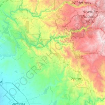
Name: Mariposa County topographic map, elevation, terrain.

Location: Mariposa County, California, United States (37.18303 -120.39544 37.90277 -119.30916)

Average elevation: 1,036 m

Minimum elevation: 48 m

Maximum elevation: 3,525 m

Other topographic maps

Click on a map to view its topography, its elevation and its terrain.

Cobb

United States > California > Lake County

Cobb is a census designated place (CDP) in Lake County, California, United States. Cobb is located 1 mile (1.6 km) northwest of Whispering Pines, at an elevation of 2,631 feet (802 m). The population was 1,778 at the 2010 census, up from 1,638 at the 2000 census.

Average elevation: 887 m

Santa Rosa

United States > California > Sonoma County

Average elevation: 136 m

Mammoth Lakes

United States > California > Mono County

Mammoth Lakes is the only incorporated town in Mono County, California, United States. It is located immediately to the east of Mammoth Mountain, at an elevation of 7,880 feet (2,400 m). As of the 2020 United States Census, the population was 7,191, reflecting a 12.7% decrease from the 2010 Census.

Average elevation: 2,682 m

Monterey County

United States > California

Average elevation: 282 m

Paradise

United States > California > Butte County

The town is spread out on a wide ridge between deep canyons formed by the west branch of the Feather River to the east and Butte Creek to the west. The Paradise area extends northward to include the unincorporated town of Magalia, as well as Stirling City, eleven miles (18 km) north. Elevation of the area…

Average elevation: 464 m

Weaverville

United States > California > Trinity County

Average elevation: 803 m

San Diego

United States > California > San Diego County

The climate in San Diego, like most of Southern California, often varies significantly over short geographical distances, resulting in microclimates. In San Diego, this is mostly because of the city's topography (the Bay, and the numerous hills, mountains, and canyons). Frequently, particularly during the "May…

Average elevation: 125 m

Riverside

United States > California > Riverside County

Riverside is the 61st-largest city in the United States, the 12th-largest city in California, and the largest city in California's Inland Empire metro area. According to the United States Census Bureau, the city has an area of 81.4 square miles (210.8 km2), of which 81.1 square miles (210 km2) is land and 0.3…

Average elevation: 372 m

Santa Barbara

United States > California > Santa Barbara County

Annual rainfall totals are highly variable and in exceptional years like 1940–1941 and 1997–1998 over 40 inches (1.0 m) of rain have fallen in a year, but in dry seasons less than 6 inches (150 mm) is not unheard of. Snow sometimes covers higher elevations of the Santa Ynez Mountains but is extremely rare…

Average elevation: 119 m

San Francisco

United States > California

Average elevation: 63 m

Anaheim

United States > California > Orange County

Average elevation: 89 m

Sierra Nevada

United States > California > Tulare County

Average elevation: 3,888 m

American River

United States > California > Sacramento County > Rancho Cordova

The North Fork is the longest tributary of the American River, at 88 miles (142 km). It begins at an elevation of about 7,900 feet (2,400 m) near Lake Tahoe in Placer County at Mountain Meadow Lake, just northeast of Granite Chief and immediately due west of Palisades Tahoe (formerly Squaw Valley) Ski Resort.…

Average elevation: 44 m

Pant

United States > California > San Bernardino County

Average elevation: 1,380 m

Death Valley

United States > California

Death Valley's Badwater Basin is the point of lowest elevation in North America, at 282 feet (86 m) below sea level. It is 84.6 miles (136.2 km) east-southeast of Mount Whitney, the highest point in the contiguous United States, with an elevation of 14,505 feet (4,421 m). On the afternoon of July 10, 1913, the…

Average elevation: 1,085 m

Bombay Beach

United States > California

The derelict "living ghost town" status of Bombay Beach has attracted many photographers, filmmakers, urban explorers, and tourists, to the point that locals tend to ask visitors if they are filmmakers that are there to shoot a documentary. The town, as well as others on the shores of the Salton Sea, is one of…

Average elevation: -61 m