
Thank you for supporting this site ❤️
Make a donation
Make a donation
Chanac-les-Mines topographic map
Click on the map to display elevation.
Thank you for supporting this site ❤️
Make a donation
Make a donation
About this map
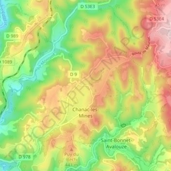
Name: Chanac-les-Mines topographic map, elevation, terrain.
Average elevation: 374 m
Minimum elevation: 223 m
Maximum elevation: 541 m
Thank you for supporting this site ❤️
Make a donation
Make a donation
Other topographic maps
Click on a map to view its topography, its elevation and its terrain.
Thank you for supporting this site ❤️
Make a donation
Make a donation
Montaignac
France > Nouvelle-Aquitaine > Corrèze > Montaignac-sur-Doustre > Montaignac
Average elevation: 596 m
Mont Bessou
France > Nouvelle-Aquitaine > Corrèze > Meymac
Avec 977 m d'altitude, c'est à la fois le point culminant du plateau de Millevaches et du département de la Corrèze.
Average elevation: 859 m
Thank you for supporting this site ❤️
Make a donation
Make a donation