
Thank you for supporting this site ❤️
Make a donation
Make a donation
Celle Ligure topographic map
Click on the map to display elevation.
Thank you for supporting this site ❤️
Make a donation
Make a donation
About this map
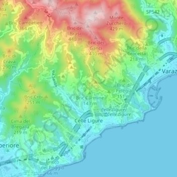
Name: Celle Ligure topographic map, elevation, terrain.
Location: Celle Ligure, Savona, Liguria, 17015, Italy (44.33148 8.51536 44.37793 8.56520)
Average elevation: 120 m
Minimum elevation: -2 m
Maximum elevation: 445 m
Thank you for supporting this site ❤️
Make a donation
Make a donation
Other topographic maps
Click on a map to view its topography, its elevation and its terrain.