
Make a donation
Bir al-Basha topographic map
Click on the map to display elevation.
Make a donation
About this map
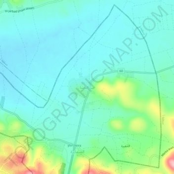
Name: Bir al-Basha topographic map, elevation, terrain.
Average elevation: 265 m
Minimum elevation: 226 m
Maximum elevation: 404 m
Make a donation
Other topographic maps
Click on a map to view its topography, its elevation and its terrain.
Dead Sea
Palestinian Territory > Judea and Samaria > Area C
The lake's surface is 430.5 metres (1,412 ft) below sea level, making its shores the lowest land-based elevation on Earth. It is 304 m (997 ft) deep, the deepest hypersaline lake in the world. With a salinity of 342 g/kg, or 34.2% (in 2011), it is one of the world's saltiest bodies of water – 9.6 times as…
Average elevation: 105 m
Make a donation
Efrat
Palestinian Territory > Judea and Samaria > Area C
Efrat (Hebrew: אֶפְרָת), or previously officially Efrata (Hebrew: אֶפְרָתָה), is an Israeli settlement in the West Bank, established in 1983 in the Judean Mountains. Efrat is located 12 kilometers (7.5 mi) south of Jerusalem, between Bethlehem and Hebron, 6.5 km (4 mi) east of the Green Line,…
Average elevation: 880 m
Beit El
Palestinian Territory > Judea and Samaria > Area C
Beit El, with a higher elevation than Jerusalem, has cool nights in summer and occasional snow in winter. The Pisgat Ya'akov neighborhood (also named Jabel Artis) has a hilltop observatory with a commanding view of the surrounding hills. Tel Aviv area and Mount Hermon can be seen on clear days.
Average elevation: 835 m
Make a donation
Talmon
Palestinian Territory > Judea and Samaria > Area C
Located at an elevation of nearly 600 metres and 18 km east of Modiin, it is organised as a community settlement and falls under the jurisdiction of Mateh Binyamin Regional Council. In 2022, it had a population of 5,379.
Average elevation: 522 m
Make a donation
Make a donation
Make a donation
Mevo Dotan
Palestinian Territory > Judea and Samaria > Area C > Shomron Regional Council
Average elevation: 264 m
Make a donation
Make a donation
Make a donation
Arvot Hayarden Regional Council
Palestinian Territory > Judea and Samaria > Area C
Average elevation: 255 m
Make a donation
Make a donation
Make a donation