
Neunkirchen am Potzberg topographic map
Interactive map
Click on the map to display elevation.
About this map
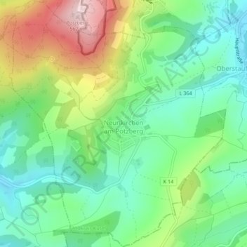
Name: Neunkirchen am Potzberg topographic map, elevation, terrain.
Average elevation: 358 m
Minimum elevation: 249 m
Maximum elevation: 561 m
Other topographic maps
Click on a map to view its topography, its elevation and its terrain.
Kappeln
Deutschland > Rheinland-Pfalz > Landkreis Kusel
Kappeln, Lauterecken-Wolfstein, Landkreis Kusel, Rheinland-Pfalz, Deutschland
Average elevation: 293 m
Kreimbach-Kaulbach
Deutschland > Rheinland-Pfalz > Landkreis Kusel
Kreimbach-Kaulbach, Lauterecken-Wolfstein, Landkreis Kusel, Rheinland-Pfalz, 67757, Deutschland
Average elevation: 304 m
Jettenbach
Deutschland > Rheinland-Pfalz > Landkreis Kusel
Jettenbach, Lauterecken-Wolfstein, Landkreis Kusel, Rheinland-Pfalz, Deutschland
Average elevation: 376 m
66901
Deutschland > Rheinland-Pfalz > Landkreis Kusel > Schönenberg-Kübelberg > Kübelberg
66901, Kübelberg, Schönenberg-Kübelberg, Oberes Glantal, Landkreis Kusel, Rheinland-Pfalz, Deutschland
Average elevation: 253 m
66887
Deutschland > Rheinland-Pfalz > Landkreis Kusel > Elzweiler
66887, Elzweiler, Kusel-Altenglan, Landkreis Kusel, Rheinland-Pfalz, Deutschland
Average elevation: 379 m
Frohnhofen
Deutschland > Rheinland-Pfalz > Landkreis Kusel
Frohnhofen, Oberes Glantal, Landkreis Kusel, Rheinland-Pfalz, Deutschland
Average elevation: 372 m
Schönenberg
Deutschland > Rheinland-Pfalz > Landkreis Kusel > Schönenberg-Kübelberg
Schönenberg, Schönenberg-Kübelberg, Oberes Glantal, Landkreis Kusel, Rheinland-Pfalz, 66901, Deutschland
Average elevation: 266 m
Körborn
Deutschland > Rheinland-Pfalz > Landkreis Kusel
Körborn, Kusel-Altenglan, Landkreis Kusel, Rheinland-Pfalz, Deutschland
Average elevation: 383 m
Ginsweiler
Deutschland > Rheinland-Pfalz > Landkreis Kusel
Ginsweiler, Lauterecken-Wolfstein, Landkreis Kusel, Rheinland-Pfalz, Deutschland
Average elevation: 279 m
Grumbach
Deutschland > Rheinland-Pfalz > Landkreis Kusel
Grumbach, Lauterecken-Wolfstein, Landkreis Kusel, Rheinland-Pfalz, 67745, Deutschland
Average elevation: 282 m
Reipoltskirchen
Deutschland > Rheinland-Pfalz > Landkreis Kusel
Reipoltskirchen, Lauterecken-Wolfstein, Landkreis Kusel, Rheinland-Pfalz, Deutschland
Average elevation: 296 m
Hinzweiler
Deutschland > Rheinland-Pfalz > Landkreis Kusel
Hinzweiler, Lauterecken-Wolfstein, Landkreis Kusel, Rheinland-Pfalz, 67756, Deutschland
Average elevation: 299 m
Einöllen
Deutschland > Rheinland-Pfalz > Landkreis Kusel
Einöllen, Lauterecken-Wolfstein, Landkreis Kusel, Rheinland-Pfalz, 67753, Deutschland
Average elevation: 323 m
Herren-Sulzbach
Deutschland > Rheinland-Pfalz > Landkreis Kusel
Herren-Sulzbach, Lauterecken-Wolfstein, Landkreis Kusel, Rheinland-Pfalz, Deutschland
Average elevation: 315 m
Dunzweiler
Deutschland > Rheinland-Pfalz > Landkreis Kusel
Dunzweiler, Oberes Glantal, Landkreis Kusel, Rheinland-Pfalz, Deutschland
Average elevation: 383 m
Altenglan
Deutschland > Rheinland-Pfalz > Landkreis Kusel
Altenglan, Kusel-Altenglan, Landkreis Kusel, Rheinland-Pfalz, Deutschland
Average elevation: 305 m
Oberjeckenbach
Deutschland > Rheinland-Pfalz > Landkreis Kusel > Unterjeckenbach
Oberjeckenbach, Unterjeckenbach, Lauterecken-Wolfstein, Landkreis Kusel, Rheinland-Pfalz, 67746, Deutschland
Average elevation: 430 m
Herchweiler
Deutschland > Rheinland-Pfalz > Landkreis Kusel
Herchweiler, Kusel-Altenglan, Landkreis Kusel, Rheinland-Pfalz, Deutschland
Average elevation: 386 m
Kusel
Deutschland > Rheinland-Pfalz > Landkreis Kusel
Kusel, Kusel-Altenglan, Landkreis Kusel, Rheinland-Pfalz, Deutschland
Average elevation: 311 m
Horschbach
Deutschland > Rheinland-Pfalz > Landkreis Kusel
Horschbach, Kusel-Altenglan, Landkreis Kusel, Rheinland-Pfalz, Deutschland
Average elevation: 325 m
Konken
Deutschland > Rheinland-Pfalz > Landkreis Kusel
Konken, Kusel-Altenglan, Landkreis Kusel, Rheinland-Pfalz, Deutschland
Average elevation: 355 m
Langenbach
Deutschland > Rheinland-Pfalz > Landkreis Kusel
Langenbach, Oberes Glantal, Landkreis Kusel, Rheinland-Pfalz, Deutschland
Average elevation: 369 m
Welchweiler
Deutschland > Rheinland-Pfalz > Landkreis Kusel
Welchweiler, Kusel-Altenglan, Landkreis Kusel, Rheinland-Pfalz, Deutschland
Average elevation: 360 m
Ruthweiler
Deutschland > Rheinland-Pfalz > Landkreis Kusel
Ruthweiler, Kusel-Altenglan, Landkreis Kusel, Rheinland-Pfalz, Deutschland
Average elevation: 325 m
Henschtal
Deutschland > Rheinland-Pfalz > Landkreis Kusel
Henschtal, Oberes Glantal, Landkreis Kusel, Rheinland-Pfalz, 66909, Deutschland
Average elevation: 305 m
Wahnwegen
Deutschland > Rheinland-Pfalz > Landkreis Kusel
Wahnwegen, Oberes Glantal, Landkreis Kusel, Rheinland-Pfalz, Deutschland
Average elevation: 337 m
Kusel-Altenglan
Deutschland > Rheinland-Pfalz > Landkreis Kusel
Kusel-Altenglan, Landkreis Kusel, Rheinland-Pfalz, Deutschland
Average elevation: 356 m
Homberg
Deutschland > Rheinland-Pfalz > Landkreis Kusel
Homberg, Lauterecken-Wolfstein, Landkreis Kusel, Rheinland-Pfalz, Deutschland
Average elevation: 343 m
Bosenbach
Deutschland > Rheinland-Pfalz > Landkreis Kusel
Bosenbach, Kusel-Altenglan, Landkreis Kusel, Rheinland-Pfalz, Deutschland
Average elevation: 348 m
Lauterecken
Deutschland > Rheinland-Pfalz > Landkreis Kusel
Lauterecken, Lauterecken-Wolfstein, Landkreis Kusel, Rheinland-Pfalz, Deutschland
Average elevation: 243 m
Burg Lichtenberg
Deutschland > Rheinland-Pfalz > Landkreis Kusel > Thallichtenberg
Burg Lichtenberg, Burgstraße, Thallichtenberg, Kusel-Altenglan, Landkreis Kusel, Rheinland-Pfalz, 66871, Deutschland
Average elevation: 346 m
Gries
Deutschland > Rheinland-Pfalz > Landkreis Kusel > Gries
Gries, Oberes Glantal, Landkreis Kusel, Rheinland-Pfalz, Deutschland
Average elevation: 275 m
Liebsthal
Deutschland > Rheinland-Pfalz > Landkreis Kusel > Quirnbach/Pfalz
Liebsthal, Quirnbach/Pfalz, Oberes Glantal, Landkreis Kusel, Rheinland-Pfalz, Deutschland
Average elevation: 324 m
Schellweiler
Deutschland > Rheinland-Pfalz > Landkreis Kusel > Schellweiler
Schellweiler, Kusel-Altenglan, Landkreis Kusel, Rheinland-Pfalz, Deutschland
Average elevation: 336 m
Rathsweiler
Deutschland > Rheinland-Pfalz > Landkreis Kusel
Rathsweiler, Kusel-Altenglan, Landkreis Kusel, Rheinland-Pfalz, Deutschland
Average elevation: 268 m
Schönenberg-Kübelberg
Deutschland > Rheinland-Pfalz > Landkreis Kusel
Schönenberg-Kübelberg, Oberes Glantal, Landkreis Kusel, Rheinland-Pfalz, 66901, Deutschland
Average elevation: 264 m
Thallichtenberg
Deutschland > Rheinland-Pfalz > Landkreis Kusel > Thallichtenberg > Thallichtenberg
Thallichtenberg, Kusel-Altenglan, Landkreis Kusel, Rheinland-Pfalz, 66871, Deutschland
Average elevation: 380 m
Offenbach-Hundheim
Deutschland > Rheinland-Pfalz > Landkreis Kusel
Offenbach-Hundheim, Lauterecken-Wolfstein, Landkreis Kusel, Rheinland-Pfalz, 67749, Deutschland
Average elevation: 250 m
Dunzweiler
Deutschland > Rheinland-Pfalz > Landkreis Kusel > Dunzweiler > Dunzweiler
Dunzweiler, Oberes Glantal, Landkreis Kusel, Rheinland-Pfalz, 66916, Deutschland
Average elevation: 377 m
Rothselberg
Deutschland > Rheinland-Pfalz > Landkreis Kusel > Rothselberg
Rothselberg, Lauterecken-Wolfstein, Landkreis Kusel, Rheinland-Pfalz, Deutschland
Average elevation: 357 m
Nußbach
Deutschland > Rheinland-Pfalz > Landkreis Kusel > Nußbach
Nußbach, Lauterecken-Wolfstein, Landkreis Kusel, Rheinland-Pfalz, 67759, Deutschland
Average elevation: 335 m
Brücken (Pfalz)
Deutschland > Rheinland-Pfalz > Landkreis Kusel
Brücken (Pfalz), Oberes Glantal, Landkreis Kusel, Rheinland-Pfalz, Deutschland
Average elevation: 297 m
Wolfstein
Deutschland > Rheinland-Pfalz > Landkreis Kusel
Wolfstein, Lauterecken-Wolfstein, Landkreis Kusel, Rheinland-Pfalz, 67752, Deutschland
Average elevation: 327 m
Rutsweiler am Glan
Deutschland > Rheinland-Pfalz > Landkreis Kusel
Rutsweiler am Glan, Kusel-Altenglan, Landkreis Kusel, Rheinland-Pfalz, Deutschland
Average elevation: 304 m
Rutsweiler an der Lauter
Deutschland > Rheinland-Pfalz > Landkreis Kusel
Rutsweiler an der Lauter, Lauterecken-Wolfstein, Landkreis Kusel, Rheinland-Pfalz, Deutschland
Average elevation: 281 m
Dittweiler
Deutschland > Rheinland-Pfalz > Landkreis Kusel
Dittweiler, Oberes Glantal, Landkreis Kusel, Rheinland-Pfalz, Deutschland
Average elevation: 308 m
Schneeweiderhof
Deutschland > Rheinland-Pfalz > Landkreis Kusel > Eßweiler
Schneeweiderhof, Eßweiler, Lauterecken-Wolfstein, Landkreis Kusel, Rheinland-Pfalz, 67754, Deutschland
Average elevation: 376 m
Medard
Deutschland > Rheinland-Pfalz > Landkreis Kusel
Medard, Lauterecken-Wolfstein, Landkreis Kusel, Rheinland-Pfalz, 67744, Deutschland
Average elevation: 249 m
Altenkirchen
Deutschland > Rheinland-Pfalz > Landkreis Kusel
Altenkirchen, Oberes Glantal, Landkreis Kusel, Rheinland-Pfalz, Deutschland
Average elevation: 335 m
Sankt Julian
Deutschland > Rheinland-Pfalz > Landkreis Kusel
Sankt Julian, Lauterecken-Wolfstein, Landkreis Kusel, Rheinland-Pfalz, Deutschland
Average elevation: 288 m