
Make a donation
Lombardy topographic map
Click on the map to display elevation.
Make a donation
Lombardy
The Lombard Alpine valleys are wider than those found in the Alps in Piedmont and Aosta Valley. Most of them are crossed by streams that descend towards the Po Valley, forming rivers that then flow into the Po on the hydrographic left. Thanks to the width of their valleys, the Lombard Alpine passes, although they are at a high altitude, are easily accessible.
Make a donation
About this map
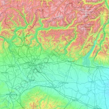
Name: Lombardy topographic map, elevation, terrain.
Location: Lombardy, Italy (44.67991 8.49785 46.63535 11.42765)
Average elevation: 797 m
Minimum elevation: 8 m
Maximum elevation: 3,853 m
Make a donation
Other topographic maps
Click on a map to view its topography, its elevation and its terrain.
Mount Vesuvius
Italy > Campania > Naples > Trecase
The volcano's slopes are scarred by lava flows, while the rest are heavily vegetated, with scrub and forests at higher altitudes and vineyards lower down.
Average elevation: 862 m
Make a donation
Matterhorn
Italy > Aosta Valley > Valtournenche
In 1999, the summit height was precisely determined to be at 4,477.54 m (14,690 ft) above sea level by using Global Positioning System technology as part of the TOWER Project (Top of the World Elevations Remeasurement) and to an accuracy of less than one centimetre, which allows future changes to be tracked.
Average elevation: 3,295 m
Casalalta
Italy > Umbria > Perugia > Collazzone
Casalalta is a frazione of the comune of Collazzone in the Province of Perugia, Umbria, central Italy. It stands at an elevation of 325 metres above sea level. At the time of the Istat census of 2001 it had 60 inhabitants.
Average elevation: 273 m
Make a donation
Mount Etna
During the first 1500 years AD, many eruptions went unrecorded (or records have been lost); among the more significant are: (1) an eruption in about 1030 AD near Monte Ilice on the lower southeast flank, which produced a lava flow that travelled about 10 km, reaching the sea north of Acireale; the villages of…
Average elevation: 1,157 m
Albana / Ibána / Albane
Italy > Friuli – Venezia Giulia > Udine / Udin / Videm > Prepotto / Prapotno / Prepot
Average elevation: 175 m
Make a donation
Make a donation
Matterhorn
Italy > Aosta Valley > Valtournenche
In 1999, the summit height was precisely determined to be at 4,477.54 m (14,690 ft) above sea level by using Global Positioning System technology as part of the TOWER Project (Top of the World Elevations Remeasurement) and to an accuracy of less than one centimetre, which allows future changes to be tracked.
Average elevation: 3,295 m
Gherdëina - Grödnertal - Val Gardena
Italy > Trentino – Alto Adige/Südtirol > South Tyrol > Urtijëi - St. Ulrich in Gröden - Ortisei
Average elevation: 1,607 m
Make a donation
Scale / Skale
Italy > Friuli – Venezia Giulia > Udine / Udin / Videm > Drenchia
Average elevation: 610 m
Make a donation
Make a donation
Matterhorn
Italy > Aosta Valley > Valtournenche
In 1999, the summit height was precisely determined to be at 4,477.54 m (14,690 ft) above sea level by using Global Positioning System technology as part of the TOWER Project (Top of the World Elevations Remeasurement) and to an accuracy of less than one centimetre, which allows future changes to be tracked.
Average elevation: 3,295 m
Nock
Italy > Trentino – Alto Adige/Südtirol > South Tyrol > Ratschings - Racines
Average elevation: 1,795 m
Make a donation
Make a donation
Make a donation
Make a donation
Gran Paradiso
Italy > Aosta Valley > Valsavarenche
The peak is the 7th highest mountain in the Graian Alps, with an elevation of 4,061 m. In the SOIUSA (International Standardized Mountain Subdivision of the Alps) the mountain belongs to an alpine subsection called "North-Eastern Graian Alps" (It:Alpi del Gran Paradiso; Fr:Alpes du Grand-Paradis) and also…
Average elevation: 3,459 m
Make a donation
Make a donation
Make a donation
Champoluc
Italy > Aosta Valley > Ayas
It is one of the 3 main villages in the commune of Ayas, together with Antagnod (where the town hall is located) and Saint-Jacques-des-Allemands. It lies at an altitude of 1568 metres in a broad flat part of the upper Ayas valley. Above Champoluc, to the East, is the Plan du Crest (1975 meters), one of the…
Average elevation: 1,968 m
Make a donation
Make a donation
Flading - Vallettina
Italy > Trentino – Alto Adige/Südtirol > South Tyrol > Ratschings - Racines
Average elevation: 2,012 m
Make a donation
Possessione Piccola
Italy > Emilia-Romagna > Bologna > San Giovanni in Persiceto
Average elevation: 25 m
Make a donation
Make a donation
Make a donation
Monte Gennaro
Italy > Lazio > Roma Capitale > San Polo dei Cavalieri
Monte Gennaro is a peak in the Monti Lucretili, in Lazio, central Italy. It has an elevation of 1,271 metres (4,170 ft) and is the highest peak visible from Rome looking eastwards. It is located in the province of Rome, in the communal territories of Palombara Sabina and San Polo dei Cavalieri.
Average elevation: 930 m
Make a donation
Rocca Calascio
At an elevation of around 1,460 metres (4,790 ft), the castle is the highest fortress in the Apennines. Built of stone and masonry exclusively for military purposes and intended only to accommodate troops and never as a residence for nobles, the fortress overlooks the Plain of Navelli at one of the highest…
Average elevation: 1,171 m
Make a donation
Make a donation
Covelo
Italy > Trentino – Alto Adige/Südtirol > Provincia di Trento > Vallelaghi
Average elevation: 834 m
Make a donation
Antlas
Italy > Trentino – Alto Adige/Südtirol > South Tyrol > Ritten - Renon > Atzwang - Campodazzo
Average elevation: 818 m
Monte Bregagno
Italy > Lombardy > Como > Cremia
Monte Bregagno is a mountain of Lombardy, Italy, It has an elevation of 2,107 metres.
Average elevation: 1,688 m
Make a donation