
Thank you for supporting this site ❤️
Make a donation
Make a donation
Bajali topographic map
Click on the map to display elevation.
Thank you for supporting this site ❤️
Make a donation
Make a donation
About this map
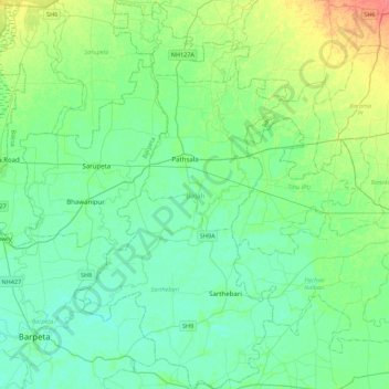
Name: Bajali topographic map, elevation, terrain.
Location: Bajali, Assam, India (26.27256 91.05314 26.66575 91.29158)
Average elevation: 47 m
Minimum elevation: 35 m
Maximum elevation: 83 m
Thank you for supporting this site ❤️
Make a donation
Make a donation
Other topographic maps
Click on a map to view its topography, its elevation and its terrain.