
Fitzgerald River National Park topographic map
Interactive map
Click on the map to display elevation.
About this map
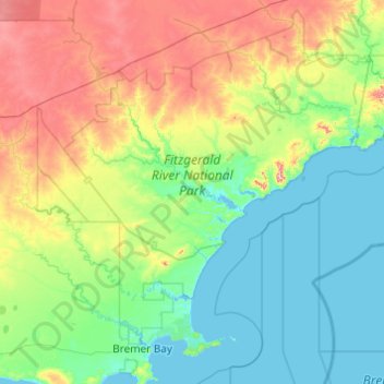
Name: Fitzgerald River National Park topographic map, elevation, terrain.
Average elevation: 116 m
Minimum elevation: -1 m
Maximum elevation: 482 m
Other topographic maps
Click on a map to view its topography, its elevation and its terrain.
Perth
Australia > Western Australia > City of Perth
Perth, the capital of Western Australia, is situated on the Swan Coastal Plain, a flat expanse of sandy soil nestled between the Indian Ocean to the west and the Darling Scarp to the east. The Darling Scarp, also known as the Darling Range, is a low escarpment that extends north–south, marking a distinct…
Average elevation: 26 m