
Thank you for supporting this site ❤️
Make a donation
Make a donation
Hasurwadi topographic map
Click on the map to display elevation.
Thank you for supporting this site ❤️
Make a donation
Make a donation
About this map
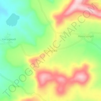
Name: Hasurwadi topographic map, elevation, terrain.
Location: Hasurwadi, Gadhinglaj, Kolhapur, Maharashtra, India (16.12721 74.35898 16.16721 74.39898)
Average elevation: 783 m
Minimum elevation: 661 m
Maximum elevation: 922 m
Thank you for supporting this site ❤️
Make a donation
Make a donation
Other topographic maps
Click on a map to view its topography, its elevation and its terrain.