
Thank you for supporting this site ❤️
Make a donation
Make a donation
Minot topographic map
Click on the map to display elevation.
Thank you for supporting this site ❤️
Make a donation
Make a donation
About this map
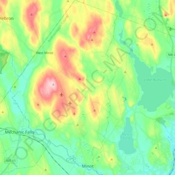
Name: Minot topographic map, elevation, terrain.
Location: Minot, Androscoggin County, Maine, 04258, United States (44.07954 -70.40181 44.21073 -70.28868)
Average elevation: 123 m
Minimum elevation: 51 m
Maximum elevation: 274 m
Thank you for supporting this site ❤️
Make a donation
Make a donation
Other topographic maps
Click on a map to view its topography, its elevation and its terrain.