
Thank you for supporting this site ❤️
Make a donation
Make a donation
Elba topographic map
Click on the map to display elevation.
Thank you for supporting this site ❤️
Make a donation
Make a donation
About this map
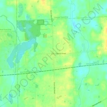
Name: Elba topographic map, elevation, terrain.
Location: Elba, Elba Township, Lapeer County, Michigan, United States (43.02154 -83.46019 43.06154 -83.42019)
Average elevation: 257 m
Minimum elevation: 245 m
Maximum elevation: 271 m
Thank you for supporting this site ❤️
Make a donation
Make a donation
Other topographic maps
Click on a map to view its topography, its elevation and its terrain.
Thank you for supporting this site ❤️
Make a donation
Make a donation
Thank you for supporting this site ❤️
Make a donation
Make a donation