
Thank you for supporting this site ❤️
Make a donation
Make a donation
Garland topographic map
Click on the map to display elevation.
Thank you for supporting this site ❤️
Make a donation
Make a donation
About this map
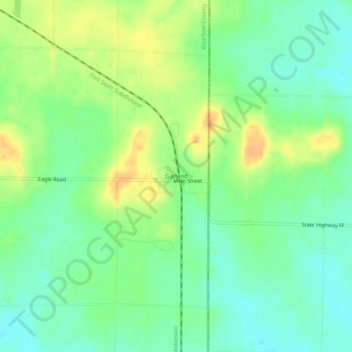
Name: Garland topographic map, elevation, terrain.
Location: Garland, Bourbon County, Kansas, 66741, United States (37.71171 -94.64246 37.75171 -94.60246)
Average elevation: 259 m
Minimum elevation: 244 m
Maximum elevation: 280 m
Thank you for supporting this site ❤️
Make a donation
Make a donation
Other topographic maps
Click on a map to view its topography, its elevation and its terrain.