
Thank you for supporting this site ❤️
Make a donation
Make a donation
Wrightington topographic map
Click on the map to display elevation.
Thank you for supporting this site ❤️
Make a donation
Make a donation
About this map
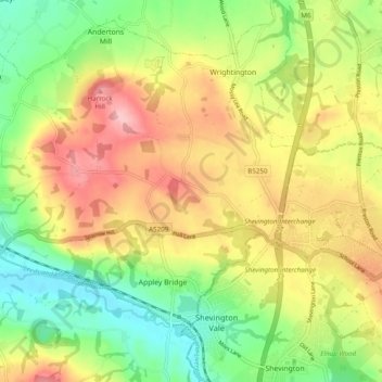
Name: Wrightington topographic map, elevation, terrain.
Average elevation: 80 m
Minimum elevation: 12 m
Maximum elevation: 157 m
Thank you for supporting this site ❤️
Make a donation
Make a donation
Other topographic maps
Click on a map to view its topography, its elevation and its terrain.
Thank you for supporting this site ❤️
Make a donation
Make a donation
Scarth Hill
United Kingdom > England > Lancashire > West Lancashire > Ormskirk
Average elevation: 58 m
Thank you for supporting this site ❤️
Make a donation
Make a donation
Bury Hey Wood
United Kingdom > England > Lancashire > West Lancashire > Appley Bridge > Robin Hood
Average elevation: 106 m
Tontine
United Kingdom > England > Lancashire > West Lancashire > Upholland > Tontine
Average elevation: 101 m
Bury Hey Wood
United Kingdom > England > Lancashire > West Lancashire > Appley Bridge > Robin Hood
Average elevation: 106 m
Thank you for supporting this site ❤️
Make a donation
Make a donation
Holt Green
United Kingdom > England > Lancashire > West Lancashire > Aughton > Holt Green
Average elevation: 35 m