
Thank you for supporting this site ❤️
Make a donation
Make a donation
Pescia topographic map
Click on the map to display elevation.
Thank you for supporting this site ❤️
Make a donation
Make a donation
About this map
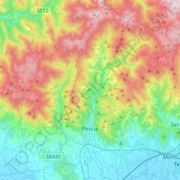
Name: Pescia topographic map, elevation, terrain.
Location: Pescia, Pistoia, Tuscany, 51017, Italy (43.85209 10.64773 44.02687 10.75498)
Average elevation: 438 m
Minimum elevation: 14 m
Maximum elevation: 1,171 m
Thank you for supporting this site ❤️
Make a donation
Make a donation
Other topographic maps
Click on a map to view its topography, its elevation and its terrain.
Thank you for supporting this site ❤️
Make a donation
Make a donation
Thank you for supporting this site ❤️
Make a donation
Make a donation
Thank you for supporting this site ❤️
Make a donation
Make a donation