
Make a donation
Saranap topographic map
Click on the map to display elevation.
Make a donation
Saranap
Saranap (until 1913, Dewing Park) is a residential census-designated place (CDP) within central Contra Costa County, California. Lying at an elevation of 180 feet (55 m), it is bounded on the south and east by portions of Walnut Creek (including the gated senior residential development Rossmoor) and on the north and west by Lafayette. Saranap's ZIP code is 94595, but is addressed "Walnut Creek, CA" for delivery purposes as this is the postal designated city name used by residents. The community is in telephone area code 925. Saranap's population as of the 2010 census was 5,202.
Make a donation
About this map
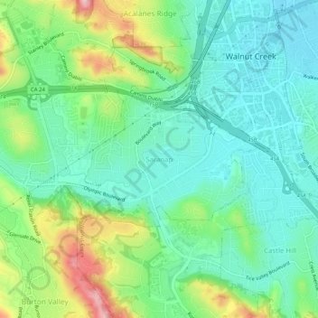
Name: Saranap topographic map, elevation, terrain.
Average elevation: 92 m
Minimum elevation: 35 m
Maximum elevation: 226 m
Make a donation
Other topographic maps
Click on a map to view its topography, its elevation and its terrain.
Bayview-Montalvin
United States > California > Contra Costa County > Pinole > Gateley
Average elevation: 17 m
Camino Tassajara
United States > California > Contra Costa County > Camino Tassajara
Camino Tassajara (Spanish for "Path of Carne Seca") is a census-designated place in Contra Costa County, California. Camino Tassajara sits at an elevation of 814 feet (248 m). The 2010 United States census reported Camino Tassajara's population was 2,197.
Average elevation: 233 m
Make a donation
Tilden Regional Park
United States > California > Contra Costa County > Orinda
Average elevation: 273 m
Morgan Territory Regional Preserve
United States > California > Contra Costa County
Average elevation: 449 m
Make a donation
Mount Diablo State Park
United States > California > Contra Costa County > Clayton
Mount Diablo is a mountain of the Diablo Range, in Contra Costa County of the eastern San Francisco Bay Area in Northern California. It is south of Clayton and northeast of Danville. It is an isolated upthrust peak of 3,849 feet (1,173 meters), visible from most of the San Francisco Bay Area. Mount Diablo…
Average elevation: 334 m
Lafayette Reservoir
United States > California > Contra Costa County > Lafayette
Average elevation: 174 m
Make a donation
John Muir National Historic Site
United States > California > Contra Costa County > Martinez > Muir
Average elevation: 94 m
Eugene O'Neill National Historic Site
United States > California > Contra Costa County > Alamo
Average elevation: 237 m