
Thank you for supporting this site ❤️
Make a donation
Make a donation
Morristown topographic map
Click on the map to display elevation.
Thank you for supporting this site ❤️
Make a donation
Make a donation
About this map
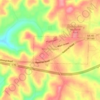
Name: Morristown topographic map, elevation, terrain.
Location: Morristown, Belmont County, Ohio, 43759, United States (40.05904 -81.08028 40.06660 -81.06071)
Average elevation: 374 m
Minimum elevation: 314 m
Maximum elevation: 409 m
Thank you for supporting this site ❤️
Make a donation
Make a donation
Other topographic maps
Click on a map to view its topography, its elevation and its terrain.
Thank you for supporting this site ❤️
Make a donation
Make a donation
Thank you for supporting this site ❤️
Make a donation
Make a donation
Thank you for supporting this site ❤️
Make a donation
Make a donation
Thank you for supporting this site ❤️
Make a donation
Make a donation