
Gütersloh topographic map
Interactive map
Click on the map to display elevation.
About this map
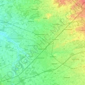
Name: Gütersloh topographic map, elevation, terrain.
Location: Gütersloh, Kreis Gütersloh, North Rhine-Westphalia, Germany (51.85597 8.28400 51.97709 8.50599)
Average elevation: 80 m
Minimum elevation: 61 m
Maximum elevation: 119 m
Gütersloh lies in the Emssandebene, south-west of the Teutoburg Forest and on the north-eastern edge of the Westphalian Basin and has no significant points of elevation. The city's lowest point is 64 metres (210 ft) above sea level on the river Ems near the Princess Royal Barracks and the highest point is 105 metres (344 ft) above sea level in the eastern township of Friedrichsdorf.