
Thank you for supporting this site ❤️
Make a donation
Make a donation
Cedar Run topographic map
Click on the map to display elevation.
Thank you for supporting this site ❤️
Make a donation
Make a donation
About this map
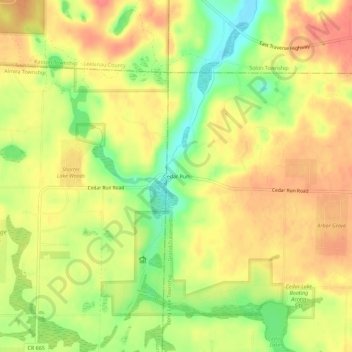
Name: Cedar Run topographic map, elevation, terrain.
Average elevation: 260 m
Minimum elevation: 222 m
Maximum elevation: 287 m
Thank you for supporting this site ❤️
Make a donation
Make a donation
Other topographic maps
Click on a map to view its topography, its elevation and its terrain.
Thank you for supporting this site ❤️
Make a donation
Make a donation
Traverse City State Park
United States > Michigan > Grand Traverse County > Traverse City
Average elevation: 180 m