
Thank you for supporting this site ❤️
Make a donation
Make a donation
Shafer topographic map
Click on the map to display elevation.
Thank you for supporting this site ❤️
Make a donation
Make a donation
About this map
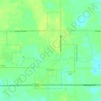
Name: Shafer topographic map, elevation, terrain.
Location: Shafer, Chisago County, Minnesota, United States (45.38177 -92.77460 45.40234 -92.73846)
Average elevation: 287 m
Minimum elevation: 278 m
Maximum elevation: 294 m
Thank you for supporting this site ❤️
Make a donation
Make a donation
Other topographic maps
Click on a map to view its topography, its elevation and its terrain.
Chain Lake
United States > Minnesota > Chisago County > North Branch > Harris
Average elevation: 281 m