
Thank you for supporting this site ❤️
Make a donation
Make a donation
Negley topographic map
Click on the map to display elevation.
Thank you for supporting this site ❤️
Make a donation
Make a donation
About this map
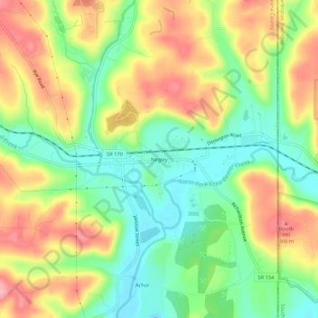
Name: Negley topographic map, elevation, terrain.
Location: Negley, Columbiana County, Ohio, 44441, United States (40.77006 -80.55896 40.81006 -80.51896)
Average elevation: 300 m
Minimum elevation: 245 m
Maximum elevation: 365 m
Thank you for supporting this site ❤️
Make a donation
Make a donation
Other topographic maps
Click on a map to view its topography, its elevation and its terrain.
Wellsville
United States > Ohio > Columbiana County
The elevation is 682 feet above sea level.
Average elevation: 269 m
Thank you for supporting this site ❤️
Make a donation
Make a donation
Thank you for supporting this site ❤️
Make a donation
Make a donation