
Thank you for supporting this site ❤️
Make a donation
Make a donation
Aubeterre-sur-Dronne topographic map
Click on the map to display elevation.
Thank you for supporting this site ❤️
Make a donation
Make a donation
Aubeterre-sur-Dronne
The highest point of the commune is at an altitude of 111m and is located on the plateau near the northern boundary. The lowest point is 38m located on the southern boundary next to the Dronne. The commune is spread between the valley of the Dronne and the top of the hill.
Thank you for supporting this site ❤️
Make a donation
Make a donation
About this map
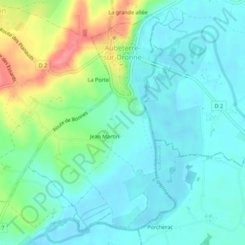
Name: Aubeterre-sur-Dronne topographic map, elevation, terrain.
Average elevation: 60 m
Minimum elevation: 38 m
Maximum elevation: 119 m
Thank you for supporting this site ❤️
Make a donation
Make a donation
Other topographic maps
Click on a map to view its topography, its elevation and its terrain.
Thank you for supporting this site ❤️
Make a donation
Make a donation
Thank you for supporting this site ❤️
Make a donation
Make a donation
Chez Landreau
France > Nouvelle-Aquitaine > Charente > Barbezieux-Saint-Hilaire
Average elevation: 62 m
Chez Landreau
France > Nouvelle-Aquitaine > Charente > Barbezieux-Saint-Hilaire
Average elevation: 62 m
Thank you for supporting this site ❤️
Make a donation
Make a donation
Thank you for supporting this site ❤️
Make a donation
Make a donation
Thank you for supporting this site ❤️
Make a donation
Make a donation