
Ille-et-Vilaine topographic map
Interactive map
Click on the map to display elevation.
About this map
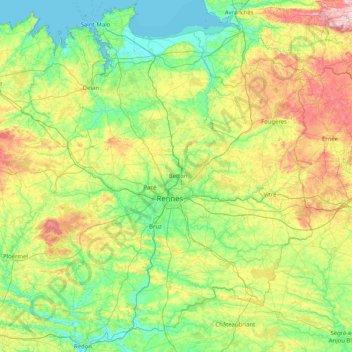
Name: Ille-et-Vilaine topographic map, elevation, terrain.
Location: Ille-et-Vilaine, Brittany, Metropolitan France, France (47.63139 -2.28898 48.72201 -1.01569)
Average elevation: 80 m
Minimum elevation: -1 m
Maximum elevation: 334 m
In the extreme south of the department the Vilaine goes through a slower decrease in elevation in a small corridor in the area of the city of Redon; in this area, the Vilaine is known for its frequent floods during its recent history, often because of too-intensive draining of agricultural areas around Rennes (some floods also affected some parts of Rennes up to the 1980s due to incorrect management of old equipment of the canal of Ille-et-Rance). To avoid these hazards within inhabited cities, some natural fields bordering the Vilaine in the south of the department are now left floodable, and works for regulating the level have been done including, small artificial lakes with derivation channels, replanting trees in the basin, better management of forests, and regulating the artificial drains made for agriculture.