
Thank you for supporting this site ❤️
Make a donation
Make a donation
Zengcheng District topographic map
Click on the map to display elevation.
Thank you for supporting this site ❤️
Make a donation
Make a donation
About this map
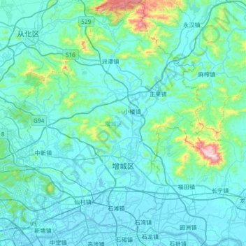
Name: Zengcheng District topographic map, elevation, terrain.
Location: Zengcheng District, Guangzhou City, Guangdong, China (23.08704 113.54166 23.62257 113.99649)
Average elevation: 106 m
Minimum elevation: -4 m
Maximum elevation: 1,251 m
Thank you for supporting this site ❤️
Make a donation
Make a donation
Other topographic maps
Click on a map to view its topography, its elevation and its terrain.