
Make a donation
Rodeo topographic map
Click on the map to display elevation.
Make a donation
About this map
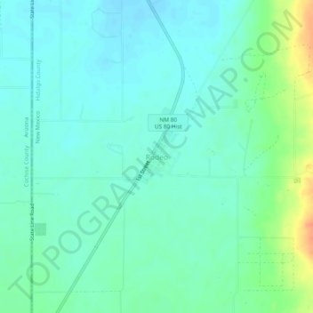
Name: Rodeo topographic map, elevation, terrain.
Location: Rodeo, Hidalgo County, New Mexico, 88056, United States (31.81644 -109.05031 31.85644 -109.01031)
Average elevation: 1,262 m
Minimum elevation: 1,251 m
Maximum elevation: 1,293 m
Make a donation
Other topographic maps
Click on a map to view its topography, its elevation and its terrain.
Lordsburg
United States > New Mexico > Hidalgo County
Typical for the more southerly and lower elevations of the Intermountain West, summers are extremely hot during the daytime, with maxima above 90 °F or 32.2 °C for over four months on an average of 122 afternoons during a full year. 100 °F or 37.8 °C is exceeded on average during 30 afternoons each year,…
Average elevation: 1,309 m