
Make a donation
Tenerife topographic map
Click on the map to display elevation.
Make a donation
Tenerife
Teide National Park, located in the center of the island, is also a UNESCO World Heritage Site. It includes Mount Teide, which has the highest elevation in Spain, and the highest elevation among all the islands in the Atlantic Ocean. It is also the third-largest volcano in the world, when measured from its base. Another geographical feature of the island, the Macizo de Anaga (massif), has been designated as a UNESCO Biosphere Reserve since 2015. Tenerife also has the largest number of endemic species in Europe.
Make a donation
About this map
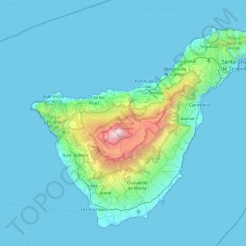
Name: Tenerife topographic map, elevation, terrain.
Location: Tenerife, Canary Islands, Spain (27.99808 -16.92593 28.60540 -16.11938)
Average elevation: 281 m
Minimum elevation: 0 m
Maximum elevation: 3,703 m
Make a donation
Other topographic maps
Click on a map to view its topography, its elevation and its terrain.