
Malaysia topographic map
Interactive map
Click on the map to display elevation.
Malaysia
The two parts of Malaysia, separated from each other by the South China Sea, share a largely similar landscape in that both Peninsular and East Malaysia feature coastal plains rising to hills and mountains. Peninsular Malaysia, containing 40 per cent of Malaysia's land area, extends 740 km (460 mi) from north to south, and its maximum width is 322 km (200 mi). It is divided between its east and west coasts by the Titiwangsa Mountains, rising to a peak elevation of 2,183 metres (7,162 ft) at Mount Korbu, part of a series of mountain ranges running down the centre of the peninsula. These mountains are heavily forested, and mainly composed of granite and other igneous rocks. Much of it has been eroded, creating a karst landscape. The range is the origin of some of Peninsular Malaysia's river systems. The coastal plains surrounding the peninsula reach a maximum width of 50 kilometres (31 mi), and the peninsula's coastline is nearly 1,931 km (1,200 mi) long, although harbours are only available on the western side.
About this map
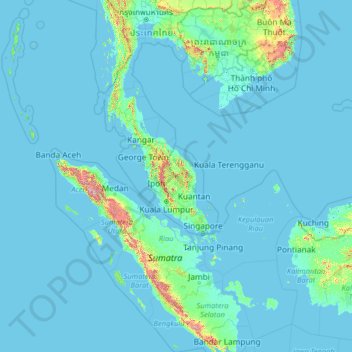
Name: Malaysia topographic map, elevation, terrain.
Location: Malaysia (0.85382 98.93721 7.66673 119.58335)
Average elevation: 52 m
Minimum elevation: -3 m
Maximum elevation: 3,124 m
Other topographic maps
Click on a map to view its topography, its elevation and its terrain.
Kampung Nelayan Sungai Haji Durani
Malaysia > Selangor > Kampung Sg Hj Dorani > Kampung Nelayan Sungai Haji Durani
Average elevation: 3 m