
Nieuwrode topographic map
Interactive map
Click on the map to display elevation.
About this map
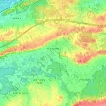
Name: Nieuwrode topographic map, elevation, terrain.
Location: Nieuwrode, Holsbeek, Leuven, Vlaams-Brabant, 3221, België (50.93086 4.78325 50.96320 4.87210)
Average elevation: 37 m
Minimum elevation: 4 m
Maximum elevation: 80 m
Other topographic maps
Click on a map to view its topography, its elevation and its terrain.
Holsbeek
België > Vlaams-Brabant > Leuven > Holsbeek
Holsbeek, Leuven, Vlaams-Brabant, Vlaanderen, 3220, België
Average elevation: 31 m
Kortrijk-Dutsel
België > Vlaams-Brabant > Leuven > Holsbeek
Kortrijk-Dutsel, Holsbeek, Leuven, Vlaams-Brabant, Vlaanderen, België
Average elevation: 43 m
Sint-Pieters-Rode
België > Vlaams-Brabant > Leuven > Holsbeek
Sint-Pieters-Rode, Holsbeek, Leuven, Vlaams-Brabant, Vlaanderen, België
Average elevation: 41 m