
Thank you for supporting this site ❤️
Make a donation
Make a donation
Lumbir topographic map
Click on the map to display elevation.
Thank you for supporting this site ❤️
Make a donation
Make a donation
About this map
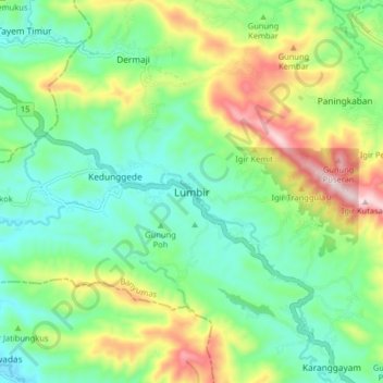
Name: Lumbir topographic map, elevation, terrain.
Location: Lumbir, Banyumas, Central Java, Java, Indonesia (-7.48547 108.92024 -7.40547 109.00024)
Average elevation: 173 m
Minimum elevation: 29 m
Maximum elevation: 470 m
Thank you for supporting this site ❤️
Make a donation
Make a donation
Other topographic maps
Click on a map to view its topography, its elevation and its terrain.
Desa Banjar Anyar Kidul Kecamatan Sokaraja
Indonesia > Central Java > Banyumas
Average elevation: 43 m
Thank you for supporting this site ❤️
Make a donation
Make a donation