
Thank you for supporting this site ❤️
Make a donation
Make a donation
Pine Creek Ranch topographic map
Click on the map to display elevation.
Thank you for supporting this site ❤️
Make a donation
Make a donation
About this map
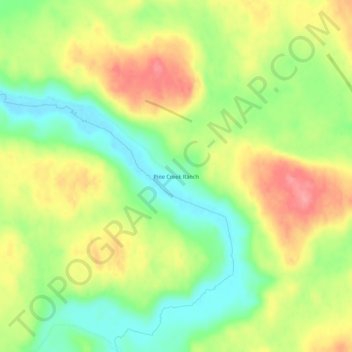
Name: Pine Creek Ranch topographic map, elevation, terrain.
Location: Pine Creek Ranch, Sheridan County, Nebraska, United States (42.45609 -102.42707 42.49609 -102.38707)
Average elevation: 1,172 m
Minimum elevation: 1,126 m
Maximum elevation: 1,223 m
Thank you for supporting this site ❤️
Make a donation
Make a donation
Other topographic maps
Click on a map to view its topography, its elevation and its terrain.