
Thank you for supporting this site ❤️
Make a donation
Make a donation
Ninevah topographic map
Click on the map to display elevation.
Thank you for supporting this site ❤️
Make a donation
Make a donation
About this map
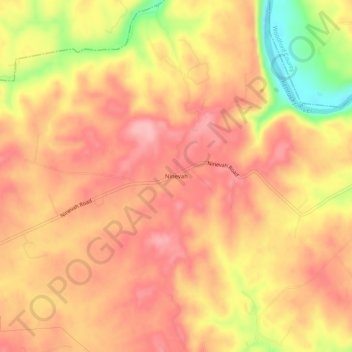
Name: Ninevah topographic map, elevation, terrain.
Location: Ninevah, Anderson County, Kentucky, United States (38.06257 -84.89884 38.10257 -84.85884)
Average elevation: 237 m
Minimum elevation: 148 m
Maximum elevation: 279 m
Thank you for supporting this site ❤️
Make a donation
Make a donation
Other topographic maps
Click on a map to view its topography, its elevation and its terrain.