
Make a donation
Argos topographic map
Click on the map to display elevation.
Make a donation
About this map
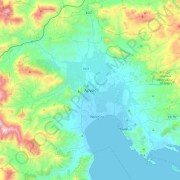
Name: Argos topographic map, elevation, terrain.
Average elevation: 322 m
Minimum elevation: -2 m
Maximum elevation: 1,572 m
Make a donation
Other topographic maps
Click on a map to view its topography, its elevation and its terrain.
Municipal Unit of Kranidi
Greece > Peloponnese, Western Greece and the Ionian > Argolis Regional Unit
Average elevation: 151 m
Municipal Unit of Argos
Greece > Peloponnese, Western Greece and the Ionian > Argolis Regional Unit
Average elevation: 212 m
Municipal Unit of Kranidi
Greece > Peloponnese, Western Greece and the Ionian > Argolis Regional Unit
Average elevation: 151 m
Municipal Unit of Kranidi
Greece > Peloponnese, Western Greece and the Ionian > Argolis Regional Unit
Average elevation: 151 m
Make a donation
Municipal Unit of Nea Kios
Greece > Peloponnese, Western Greece and the Ionian > Argolis Regional Unit
Average elevation: 2 m
Municipal Unit of Mykines
Greece > Peloponnese, Western Greece and the Ionian > Argolis Regional Unit
Average elevation: 312 m