
Make a donation
Ventura topographic map
Click on the map to display elevation.
Make a donation
About this map
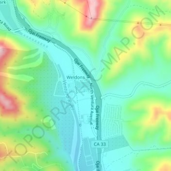
Name: Ventura topographic map, elevation, terrain.
Location: Ventura, Ventura County, California, United States (34.34250 -119.29721 34.34468 -119.29411)
Average elevation: 120 m
Minimum elevation: 42 m
Maximum elevation: 302 m
Make a donation
Other topographic maps
Click on a map to view its topography, its elevation and its terrain.
Make a donation
Newbury Park
United States > California > Ventura County > Thousand Oaks
Newbury Park can be described as a town,[6] community,[94] or section[9] mostly within the Thousand Oaks city limits in addition to rural areas west of Thousand Oaks. Newbury Park is bordered by Lynn Road in the east and the Conejo Grade on the west. It borders the Santa Monica Mountains in the south, while…
Average elevation: 262 m
Make a donation
Make a donation
Make a donation
Make a donation
Casitas Springs
United States > California > Ventura County > Ventura > Casitas Springs
Average elevation: 182 m
Castlewood at Big Sky
United States > California > Ventura County > Simi Valley > Castlewood at Big Sky
Average elevation: 360 m
Make a donation
Ventu Park
United States > California > Ventura County > Thousand Oaks > Newbury Park
Average elevation: 250 m
Greenwich Village
United States > California > Ventura County > Thousand Oaks
Average elevation: 275 m