Flatwood topographic map
Interactive map
Click on the map to display elevation.
About this map
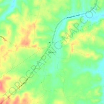
Name: Flatwood topographic map, elevation, terrain.
Location: Flatwood, Adair County, Kentucky, United States (37.02784 -85.38163 37.06784 -85.34163)
Average elevation: 252 m
Minimum elevation: 220 m
Maximum elevation: 292 m
Other topographic maps
Click on a map to view its topography, its elevation and its terrain.
Cane Valley
United States > Kentucky > Adair County
Cane Valley, Adair County, Kentucky, United States
Average elevation: 255 m
Barnett Springs
United States > Kentucky > Adair County
Barnett Springs, Adair County, Kentucky, United States
Average elevation: 285 m
Columbia
United States > Kentucky > Adair County
Columbia, Adair County, Kentucky, 42728, United States
Average elevation: 241 m
Pickett
United States > Kentucky > Adair County > Pickett
Pickett, Adair County, Kentucky, 42742, United States
Average elevation: 224 m
Chance
United States > Kentucky > Adair County > Chance
Chance, Adair County, Kentucky, United States
Average elevation: 276 m
Breeding
United States > Kentucky > Adair County
Breeding, Adair County, Kentucky, United States
Average elevation: 302 m