
Make a donation
Vorokhta topographic map
Click on the map to display elevation.
Make a donation
Vorokhta
Located at an elevation of 800 metres above sea level, it is known for its close ties to the Hutsuls – an ethno-cultural group of Ukrainians who live in the Carpathians, and is often regarded as a Hutsul capital.
Make a donation
About this map
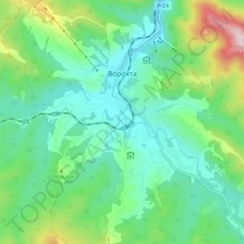
Name: Vorokhta topographic map, elevation, terrain.
Average elevation: 860 m
Minimum elevation: 720 m
Maximum elevation: 1,263 m
Make a donation
Other topographic maps
Click on a map to view its topography, its elevation and its terrain.
Make a donation
Make a donation
Bukovel
Ukraine > Ivano-Frankivsk Oblast > Polianytsia
Bukovel is the largest ski resort in Eastern Europe situated in Ukraine, in Nadvirna Raion, Ivano-Frankivsk Oblast (province) of western Ukraine. A part of it is in state property. The resort is located almost on the ridge-lines of the Carpathian Mountains at elevation of 900 m (3,000 ft) above the sea level…
Average elevation: 1,009 m
Make a donation
Bukovel
Ukraine > Ivano-Frankivsk Oblast > Polianytsia
Bukovel (Ukrainian: Буковель) is the largest ski resort in Eastern Europe situated in Ukraine, in Nadvirna Raion, Ivano-Frankivsk Oblast (province) of western Ukraine. A part of it is in state property. The resort is located almost on the ridge-lines of the Carpathian Mountains at elevation of 900 m…
Average elevation: 1,009 m
Make a donation