
Thank you for supporting this site ❤️
Make a donation
Make a donation
Blambangan Umpu topographic map
Click on the map to display elevation.
Thank you for supporting this site ❤️
Make a donation
Make a donation
About this map
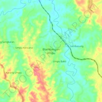
Name: Blambangan Umpu topographic map, elevation, terrain.
Location: Blambangan Umpu, Way Kanan, Lampung, Sumatra, Indonesia (-4.54872 104.47278 -4.46872 104.55278)
Average elevation: 67 m
Minimum elevation: 36 m
Maximum elevation: 126 m
Thank you for supporting this site ❤️
Make a donation
Make a donation