
卡拉乡 topographic map
Interactive map
Click on the map to display elevation.
About this map
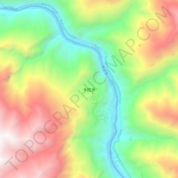
Name: 卡拉乡 topographic map, elevation, terrain.
Location: 卡拉乡, 木里藏族自治县, 凉山彝族自治州, 四川省, 中国 (28.29874 101.30843 28.37874 101.38843)
Average elevation: 2,874 m
Minimum elevation: 1,889 m
Maximum elevation: 4,212 m
Other topographic maps
Click on a map to view its topography, its elevation and its terrain.