
Thank you for supporting this site ❤️
Make a donation
Make a donation
Bhagirathi River topographic map
Click on the map to display elevation.
Thank you for supporting this site ❤️
Make a donation
Make a donation
Bhagirathi River
The Bhilangna itself rises at the foot of the Khatling Glacier (elevation 3,717 m (12,195 ft)) approximately 50 km (31 mi) south of Gaumukh.
Thank you for supporting this site ❤️
Make a donation
Make a donation
About this map
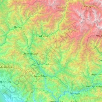
Name: Bhagirathi River topographic map, elevation, terrain.
Location: Bhagirathi River, Uttarakhand, India (30.14509 78.31487 31.04715 79.08187)
Average elevation: 2,256 m
Minimum elevation: 448 m
Maximum elevation: 6,889 m
Thank you for supporting this site ❤️
Make a donation
Make a donation
Other topographic maps
Click on a map to view its topography, its elevation and its terrain.
Thank you for supporting this site ❤️
Make a donation
Make a donation
Thank you for supporting this site ❤️
Make a donation
Make a donation
Thank you for supporting this site ❤️
Make a donation
Make a donation