
Thank you for supporting this site ❤️
Make a donation
Make a donation
Moses Coulee topographic map
Click on the map to display elevation.
Thank you for supporting this site ❤️
Make a donation
Make a donation
About this map
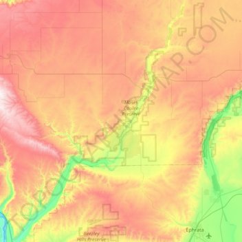
Name: Moses Coulee topographic map, elevation, terrain.
Average elevation: 665 m
Minimum elevation: 172 m
Maximum elevation: 1,198 m
Thank you for supporting this site ❤️
Make a donation
Make a donation
Other topographic maps
Click on a map to view its topography, its elevation and its terrain.
East Wenatchee Bench
United States > Washington > Douglas County > East Wenatchee
Average elevation: 296 m