
Thank you for supporting this site ❤️
Make a donation
Make a donation
Vijayawada topographic map
Click on the map to display elevation.
Thank you for supporting this site ❤️
Make a donation
Make a donation
Vijayawada
Vijayawada lies on the banks of Krishna river, covered by hills and canals. and at an altitude of 11 m (36 ft) above sea level. Three canals originating from the north side of the Prakasam Barrage reservoir — Eluru, Bandar, and Ryves — flow through the city.
Thank you for supporting this site ❤️
Make a donation
Make a donation
About this map
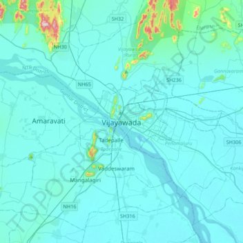
Name: Vijayawada topographic map, elevation, terrain.
Location: Vijayawada, NTR, Andhra Pradesh, 520001, India (16.34876 80.45851 16.66876 80.77851)
Average elevation: 36 m
Minimum elevation: 7 m
Maximum elevation: 447 m
Thank you for supporting this site ❤️
Make a donation
Make a donation
Other topographic maps
Click on a map to view its topography, its elevation and its terrain.