
Make a donation
Mevaseret Zion topographic map
Click on the map to display elevation.
Make a donation
About this map
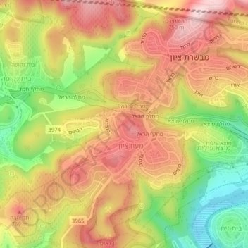
Name: Mevaseret Zion topographic map, elevation, terrain.
Average elevation: 696 m
Minimum elevation: 541 m
Maximum elevation: 816 m
Make a donation
Other topographic maps
Click on a map to view its topography, its elevation and its terrain.
Jerusalem
Jerusalem is situated on the southern spur of a plateau in the Judaean Mountains, which include the Mount of Olives (East) and Mount Scopus (North East). The elevation of the Old City is approximately 760 m (2,490 ft). The whole of Jerusalem is surrounded by valleys and dry riverbeds (wadis). The Kidron,…
Average elevation: 520 m
Make a donation
Make a donation
Make a donation
Make a donation
Make a donation
Make a donation
Make a donation
Zecharya
Israel > Jerusalem District > Mate Yehuda Regional Council
The Tell rests upon a high hilltop, whereas the village lay on a slightly elevated part of the valley below, on the northwest side of the hill. The hill rises to a maximum elevation of 372 meters above sea level, with a mean elevation of approximately 275 meters above sea level. The village lay next to the…
Average elevation: 278 m
Make a donation
Make a donation
Make a donation