
Thank you for supporting this site ❤️
Make a donation
Make a donation
Tsuen Wan topographic map
Click on the map to display elevation.
Thank you for supporting this site ❤️
Make a donation
Make a donation
About this map
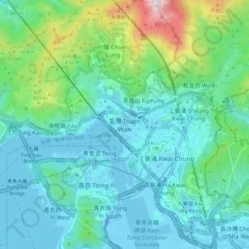
Name: Tsuen Wan topographic map, elevation, terrain.
Average elevation: 185 m
Minimum elevation: -24 m
Maximum elevation: 949 m
Thank you for supporting this site ❤️
Make a donation
Make a donation
Other topographic maps
Click on a map to view its topography, its elevation and its terrain.
Ma Wan
China > Hong Kong > Tsuen Wan District > Wang Lung Mei > Ma Wan Main Street Village
Average elevation: 12 m