
Thank you for supporting this site ❤️
Make a donation
Make a donation
Kiona topographic map
Click on the map to display elevation.
Thank you for supporting this site ❤️
Make a donation
Make a donation
About this map
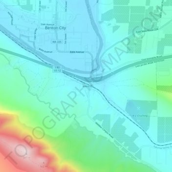
Name: Kiona topographic map, elevation, terrain.
Location: Kiona, Benton County, Washington, 99320, United States (46.22958 -119.49752 46.26958 -119.45752)
Average elevation: 224 m
Minimum elevation: 139 m
Maximum elevation: 589 m
Thank you for supporting this site ❤️
Make a donation
Make a donation
Other topographic maps
Click on a map to view its topography, its elevation and its terrain.